The Climate and Geography of New Orleans
Surrounded by water on three sides, New Orleans sits on a peninsula in Southern Louisiana. The Gulf of Mexico occupies the southern and eastern sides, and Lake Pontchartrain, which is connected to an opening in the Gulf of Mexico (Lake Borgne), occupies the northern side. The middle of the city curves around the Mississippi River, contributing to the nickname of the “Crescent City.” New Orleans also sits in Orleans Parish, with parishes such as St. Charles, St. John, St. James, Jefferson, Plaquemines, St. Bernard, and St. Tammany bordering it. Swamps, marshes, and lakes make up most of the land in these areas. New Orleans sits mostly under sea level, and has a humid, semi-tropical climate that is kept from extremes from the water bordering it. Rain is common throughout the year, and waterspouts appear frequently as well.
On the 29th of August in 2005, one of the most devastating hurricanes to ever hit the U.S. stroke. This was Hurricane Katrina. New Orleans was the city that was hit the hardest by this storm, and the geography and climate of this area did nothing to help. Already having a humid climate, New Orleans experiences a ton of rain year round. August is one of the rainiest months for New Orleans, and the many swamps and marshes of this area already had close to the maximum capacity of water they could possibly hold. Then Hurricane Katrina hit. Flooding from Lake Pontchartrain, the Mississippi River, and the many small lakes that were already on the brink of overflowing, flew into all parts of New Orleans, putting most of it underwater. Water flowed downhill into the many neighborhoods of the city with ease, as most of the city is below sea level. This storm was disastrous to the entirety of New Orleans and the areas surrounding it, and was one of the most costly hurricanes to ever hit the United States. This is all mostly thanks to the less than ideal climate and geography of New Orleans.
On the 29th of August in 2005, one of the most devastating hurricanes to ever hit the U.S. stroke. This was Hurricane Katrina. New Orleans was the city that was hit the hardest by this storm, and the geography and climate of this area did nothing to help. Already having a humid climate, New Orleans experiences a ton of rain year round. August is one of the rainiest months for New Orleans, and the many swamps and marshes of this area already had close to the maximum capacity of water they could possibly hold. Then Hurricane Katrina hit. Flooding from Lake Pontchartrain, the Mississippi River, and the many small lakes that were already on the brink of overflowing, flew into all parts of New Orleans, putting most of it underwater. Water flowed downhill into the many neighborhoods of the city with ease, as most of the city is below sea level. This storm was disastrous to the entirety of New Orleans and the areas surrounding it, and was one of the most costly hurricanes to ever hit the United States. This is all mostly thanks to the less than ideal climate and geography of New Orleans.
These are some basic geographic maps of New Orleans. New Orleans has an area of 181 square miles.
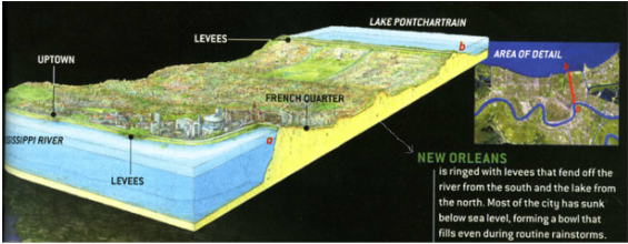
Lake Pontchartrain, a primary source of flooding during Hurricane Katrina, is to the north, while the river cuts through the city is the Mississippi. The levee of New Orleans is to the north of the city.
Lake Pontchartrain, a primary source of flooding during Hurricane Katrina, is to the north, while the river cuts through the city is the Mississippi. The levee of New Orleans is to the north of the city.
These are some maps of the parishes, or counties, surrounding New Orleans.
These areas were all severely affected by Hurricane Katrina, which caused severe damage and displaced a lot of people. Baton Rouge, which sits on the left side of the first map, was a popular destination for refugees, as it was not as severely affected, most likely due to its more ideal position and climate.
These areas were all severely affected by Hurricane Katrina, which caused severe damage and displaced a lot of people. Baton Rouge, which sits on the left side of the first map, was a popular destination for refugees, as it was not as severely affected, most likely due to its more ideal position and climate.
Elevation:
Ranges from 5 feet below sea level to 15 feet above
5 feet above sea level is the mean elevation
The first map shows the location of the many neighborhoods in New Orleans. Notice that the Lower 9th Ward, an area decimated by Hurricane Katrina due to flooding, slopes down like a ramp right by the Mississippi River. This made the Lower 9th Ward an ideal place for water to flow after the levee broke during the storm. The other maps explain this more in detail.
Made in Google Docs
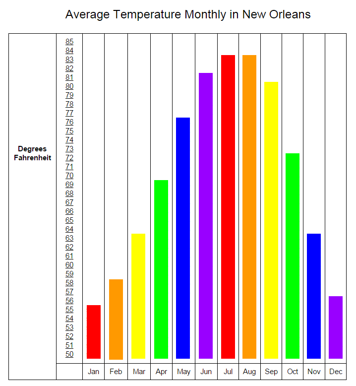
Average Temperature Annually-
51.3 degrees Fahrenheit in January 81.9 degrees Fahrenheit in July 68.1 degrees Fahrenheit year round August is fourth hottest month in New Orleans. More condensation happens than usual during this time because of the warm temperatures, contributing to the amount of rainfall illustrated to the left during this month. Future of New Orleans |
Made in Google Docs
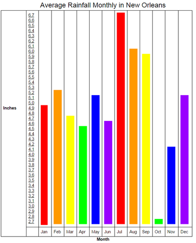
Average Annual Precipitation-
61.88 inches August is the third rainiest month of the year in New Orleans, and rain had already been down pouring on the city prior to when the hurricane struck. |
New Orleans is one of the lowest places sea level wise in U.S.A. New Orleans, or "The Big Easy" is already 17 feet below the normal sea level and is still getting lower at a rate of 1 inch a year! When you think of The Big Easy, you should see a giant lake that was emptied out and turned into a city while it is constantly being built on, pushed down, and cleared out. If the levees were to give way again, you would just be filling up a giant lake which is practically impossible to drain. Even rain can clog up in awkward places and cause little ponds and build up. So i would say the elevation of New Orleans has the most potential to cause another natural disaster. New Orleans has proposed many ideas to attack this threat. One idea involved selling the French Quarter to disney, thereby moving the port 150 miles upstream. Others involved rebuilding things smaller and higher. All these suggestions and The Big Easy is still just getting even bigger and easier to flood.
Sources-
http://www.neworleanscvb.com/visit/weather/
http://www.usclimatedata.com/climate/new-orleans/louisiana/united-states/usla0338
http://www.city-data.com/us-cities/The-South/New-Orleans-Geography-and-Climate.html
https://upload.wikimedia.org/wikipedia/commons/c/c2/Landsat_new_orleans_nfl.jpg
https://upload.wikimedia.org/wikipedia/commons/7/77/New_Orleans_elevation_relative_to_Lake_Pontchartrain.jpg
https://upload.wikimedia.org/wikipedia/commons/7/76/Louisiana_parishes_map_magnified.jpg
